Complete ecotouristic information database on national parks of Bali (Indonesia).
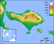
Bali is an island and province of Indonesia. The province includes the island of Bali and a few smaller  neighbouring islands, notably Nusa Penida. It is located at the westernmost end of the Lesser Sunda Islands, between Java to the west and Lombok to the east. Its capital of Denpasar is located at the southern part of the island.
Total population was 4,225,000 in the 2014 census.
The island of Bali lies 3.2 km east of Java, and is approximately 8 degrees south of the equator. Bali and Java are separated by the Bali Strait. East to west, the island is approximately 153 km wide and spans approximately 112 km north to south; administratively it covers 5,780 km2.
Bali's central mountains include several peaks over 3,000 metres in elevation. The highest is Mount Agung (3,031 m), which is an active volcano. The longest river, Ayung River, flows approximately 75 km. The island is surrounded by coral reefs. Beaches in the south tend to have white sand while those in the north and west have black sand.
To the east, the Lombok Strait separates Bali from Lombok and marks the biogeographical division between the fauna of the Indomalayan ecozone and the distinctly different fauna of Australasia. The transition is known as the Wallace Line. Bali lies just to the west of the Wallace Line, and thus has a fauna that is Asian in character, with very little Australasian influence, and has more in common with Java than with Lombok. An exception is the yellow-crested cockatoo, a member of a primarily Australasian family.
Detailed information on Bali (Indonesia) national parks.
There is a database of Bali national parks available. If you have any question or request you can send it by attached Informative Form.