Complete ecotouristic information database on national parks of Borneo (Indonesia).
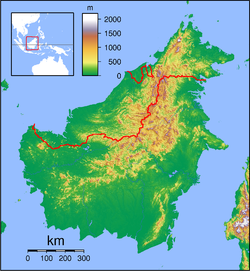
With its area of 743,330 square kilometres is Borneo the third-largest island in the world and the largest  island of Asia. At the geographic centre of Maritime Southeast Asia, in relation to major Indonesian islands, it is located north of Java, west of Sulawesi, and east of Sumatra.
The island is divided among three countries: Brunei and Malaysia on the north, and Indonesia to the south. Approximately 73% of the island is Indonesian territory.
Borneo is surrounded by the South China Sea to the north and northwest, the Sulu Sea to the northeast, the Celebes Sea and the Makassar Strait to the east, and the Java Sea and Karimata Strait to the south. To the west of Borneo are the Malay Peninsula. To the northeast are the Philippines. Its highest point is Mount Kinabalu in Sabah, Malaysia, with an elevation of 4,095 m.
The largest river system is the Kapuas in West Kalimantan, with a length of 1,143 km. Other major rivers include the Mahakam in East Kalimantan (980 km long), the Barito in South Kalimantan (880 km long).
The Borneo rainforest is 130 million years old, making it one of the oldest rainforests in the world. There are about 15,000 species of flowering plants with 3,000 species of trees (267 species are dipterocarps), 221 species of terrestrial mammals and 420 species of resident birds in Borneo. There are about 440 freshwater fish species in Borneo (about the same as Sumatra and Java combined). It is the centre of the evolution and distribution of many endemic species of plants and animals. The Borneo rainforest is one of the few remaining natural habitats for the endangered Bornean orangutan. It is an important refuge for many endemic forest species, including the Asian elephant, the Sumatran rhinoceros, the Bornean clouded leopard, the Hose's civet and the dayak fruit bat.
In 2010 the World Wide Fund for Nature stated that 123 species have been discovered in Borneo since the "Heart of Borneo" agreement was signed in 2007. The WWFN has classified the island into seven distinct ecoregions. Most are lowland regions:
- Borneo lowland rain forests cover most of the island, with an area of 427,500 square kilometres;
- Borneo peat swamp forests;
- Kerangas or Sundaland heath forests;
- Southwest Borneo freshwater swamp forests;
- Sunda Shelf mangroves.
- The Borneo montane rain forests lie in the central highlands of the island, above the 1,000 metres elevation.
The island historically had extensive rainforest cover, but the area was reduced due to heavy logging for the Malaysian and Indonesian plywood industry. Half of the annual global tropical timber acquisition comes from Borneo. Palm oil plantations have been widely developed and are rapidly encroaching on the last remnants of primary rainforest. Forest fires of 1997 to 1998, started by the locals to clear the forests for crops and kept going by an exceptionally dry El Niño season during that period, further reduced the rainforest.
There are many national parks in the Borneo territory. Some of them are considered to be extraordinary important because of some critically endangered animals and plants species occurrence. Several national parks are protected by UNESCO.
Detailed information on Borneo (Indonesia) national parks.
There is a database of Borneo national parks available. If you have any question or request you can send it by attached Informative Form.